
We've been out testing iPad charting software. Here's a first impression of the choices available on the market

We’ve been testing iPad charts and navigation software. There are now a lot of programs for the iPad and other tablets – Navionics, Transas iSailor, iNavX, Memory Map, Garmin, Imray and SailTimer among them.
Matt and I spent the best part of two days trying out different types and our impressions are mixed. Some are excellent and, for the functionality and convenience, superb value. But perhaps a few developers have been in a hurry to release tablet software, but some of it is quite disappointing.
See our report on the test and reviews of the seven iPad navigation apps tested
The area that’s prone to most of a let down, for me, is navigation functions. Some of these programs invite you to make a route with waypoints, but then don’t automatically follow that route, or provide you with updating range, bearing, cross-track error, etc, or even move from one waypoint to the other. The Garmin software is one example.
One or two make it difficult, or even impossible, to view ship’s position in lat and long, which to me is the minimum requirement. A sad culprit is Navionics, an otherwise excellent product. This provides no position co-ordinates for you to record in your logbook or mark on a paper chart [ie current GPS position, please see the comments section below]. Please note, Navionics: this surely must be so easy to remedy. You’ve stripped out the Number 1 point of having a handheld GPS.
Some of these programs use raster charts that are scanned, flat versions of the paper products, eg Memory Map (using UKHO Admiralty products) and Imray. These don’t have interactive chart features. Others are vector charts, digitised versions that allow you to click on chart features and objects and learn more.
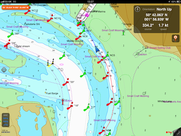
An example of a vector chart, iSailor from Transas, showing track, boat position (blue arrow) and boat’s lat/long, course and speed in the top right corner
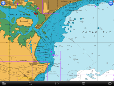
A raster chart from Memory Map, which is from an Admiralty chart. Boat position is shown by the red circle and, provided you’ve paid for and downloaded the Poole Harbour chart as well the software can zoom from this approaches chart (Portland Bill to the Needles folio) to closer detail
Some of the better programs allow you to access or download GRIB files and tidal information – Navionics and Garmin lead here, with Navionics the winner in terms of providing real time tidal height graphs for secondary ports and a nice feature that lets you scroll forward to find out the rise of tide at any time of your choosing up to several days ahead.
The pricing is disconcertingly variable and that obviously plays a big part in choosing software. For example, Navionics HD charts for all of the UK and Holland cost £37.99, which is great value and at least partly justifies the cost of an iPad to sometime small boat sailors like me.
In contrast, it would cost £215 to get all the Transas iSailor charts for UK because they cost £11.99 each and there are 18 portfolios. But the iSailor charts are excellent, the navigation module is, in my opinion, better than Navionics, and if the area you intend cruising in is relatively confined, perhaps this might be a better bet. Again, to take an example, the chart portfolio covering Teignmouth to Falmouth is one £11.99 download, so for some that would be a cheaper choice than Navionics UK and Holland.
Let’s just say the pros and cons of each program make getting the best product for what you want to do surprisingly complicated. But after our tests we have narrowed down our favourites. The funny thing is that although I started with Navionics and have happily been using that for several years, I’m sold on the idea of having two separate nav software programs for the iPad which would dovetail with complementary functions.
We also have a video explaining what iPad nav can do for you, and what to look for.
Am I mad for using an iPad for navigation?
A few last comments for now, though. Several people have asked if I’m mad using an iPad for navigation at all. Is it really sensible as a standalone device?
My answer is no, it’s not mad, and yes it is potentially a valuable standalone device. The iPad is, after all, a handheld GPS by any other name, and we were pretty happy to have those not so long ago. If you happen to be a small boat sailor, a dayboat sailor, or regularly charter it’s an ideal back-up or addition. All you need is one of the many waterproof or splashproof covers and a means of recharging at the end of the day.
As for GPS accuracy, the only time I’ve ever had a problem was when using it down below on a steel boat, when I would lose the fix. I’ve not yet had a problem on a glassfibre boat. And this is worth knowing: the iPad does NOT need to use wifi or be in mobile phone reception to get an accurate fix. It works just fine when there’s no signal.
All these programs use charts that need to be downloaded and stored locally on the iPad, so even beyond internet access the GPS can place you on a chart. That’s in contrast to Apple mapping, or Google or Bing, where your GPS position has to be placed on maps that can only be accessed online. You just have to be sure you buy the 3G iPad, as that is the one that has the built-in GPS aerial.
To all those who point out that electronic charts have a fair few inaccuracies, that is quite correct. But it’s not unique to the iPad or any tablet; these errors exist on same electronic charts used on wired-in yacht chartplotters, and indeed there can be – and are – errors on paper charts as well.
The iPad versions are no less or more magical than any of these, and it would be foolish to navigate exclusively or be over-reliant on any of them without using good old-fashioned pilotage techniques and the Mk1 eyeball.
In fact what is really important is that all the electronic devices on board don’t completely distract us from practising the essential art of keeping your eye in. If you’ve got your head stuck in front of a ‘black mirror’ all day long you’ll never spot important clues such as changes in water texture or colour, current running against a buoy or maker, or be adept at gauging distance off.
It’s quite easy to get rusty and lose the knack of being able to scan the horizon and pick out vessels and distant objects. And there’s the scenery, the sea birds, the spray from the bow wave, the fresh air and all that space and freedom to enjoy and appreciate.
These mobile chartplotters definitely have a place, but you do need to look up and look out of a boat, for safety reasons as well as for sheer pleasure. I know only too well how easy it is to get mesmerised by technology, but we all spend too much of our lives looking at screens as it is.