
Meteorologist and experienced sailor Chris Tibbs explains why a cold front is more significant when ocean cruising than a warm front
Outside the tropics much of our sailing takes place in the disturbed westerly airflow that generates depressions, and within the depressions (or lows) the most active feature is usually the cold front.
On many weather charts the warm front can be small and quite insignificant and may not be shown at all as the fronts are boundaries between different air masses. Classical theory indicates that the depression forms with fronts and sectors, but in reality nature is far more complex. For instance yachts sailing back from the Caribbean will encounter active cold fronts that move rapidly from the US east coast driven by strong winds.
This makes cold fronts one of the more interesting features that we sail through as they will arrive with heavy rain, squally showers and a significant veer in the wind. There will then be a clearing of the sky with some sunshine before a build-up of squally showers.
Historically, cold fronts were known as squall lines, which is an apt description.
Although each front varies there is a recognisable pattern: typically a band of heavy rain with large raindrops along with an increase in the wind and increased gustiness.
The rain is from large cumulonimbus clouds embedded in the front and an active front may contain thunderstorms. As the front comes through the wind becomes gustier and you get a veer in the wind, which is quite significant – maybe 40° or more.
This is a rapid veer (the wind will back in the Southern Hemisphere) and shortly afterwards the sky will clear, allowing bright sunshine with an increase in the build-up of cumulus clouds, eventually giving squally showers; the barometer will give a jump or kick as it starts to rise. As the cold front is the leading edge of the cold air, the temperature drops along with the humidity.
Strongest wind
But what of the wind? Behind cold fronts we often find the strongest wind in a depression, but there may be a lull of 20 minutes or more before the strong wind kicks in; however at other times it hits hard straight away.
GRIB files have become a great tool for navigators, but there are times when we need extra information and fronts are one of these times. Our wind swing with a cold front will be abrupt, but shown on GRIB files the change in wind direction will be more gradual and averaged over time.

The lack of a visible front illustrated on GRIB files, can be misleading
The lack of a visible front on GRIB files can be misleading, but by comparing them with synoptic charts you can determine quite accurately just when a front will pass through. You can also get help by downloading rainfall rates (readily available in GRIB file format) and there is also something called CAPE which can also be found in GRIB file format.
CAPE stands for convective available potential energy; it is measured in joules per kilogram, J/kg, and the greater the reading the higher the potential for severe weather. You can use it to estimate the instability of the atmosphere, which in turn indicates a likelihood of gusts and squalls. An active cold front with a great deal of vertical movement will be represented by a high value of CAPE.
Useful when crossing oceans
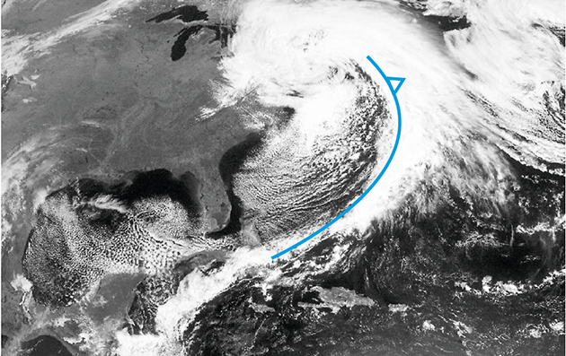
Cold fronts look impressive on satellite imagery. They are easily identifiable and are actual rather than model predictions, making them very useful when crossing oceans.
The potential for strong winds and squalls make them significant features and with a predictable change in the wind they can be tactically very useful. When we were beating in the Southern Ocean during the BT Global Challenge we found that the advantage to be found with the wind swing in the front had to be balanced against the squall activity found there.
During the race we found the strongest wind in cold fronts, and twice had to heave-to in squalls with the wind in excess of 80 knots.
Cold fronts can also kick up a dangerous sea state because of the changing wind directions; swell from the south-west meets the building sea from the north-west. This is particularly dangerous in north Biscay where the continental shelf extends well into the Bay and has caused problems for many a racing and cruising yacht.
Once on an early delivery back from the Caribbean we were approaching the Azores; after a period of near-gale force south-westerly wind we were hit by an active cold front. The wind was not too bad, but the cross swell eventually took its toll and a monster wave rolled the boat through 360°, bending the rig and causing chaos below.

Chris Tibbs is a meteorologist and weather router, as well as a professional sailor and navigator, forecasting for Olympic teams and the ARC rally. He is currently on his own circumnavigation with his wife, Helen. His series of Weather Briefings can be seen here
See also:
Chris Tibbs prepares his own boat for an Atlantic crossing
The best route for an Atlantic crossing
Taking the northerly route across the Atlantic
Offshore weather planning: options for receiving weather data at sea
as well as Chris Tibbs’s series of Weather Briefings