
It is now commonplace to see iPads and other tablets being used for navigation, but there is still quite a difference between the best and worst apps you can download. Pip Hare tests and compares seven popular apps for ipad and android.
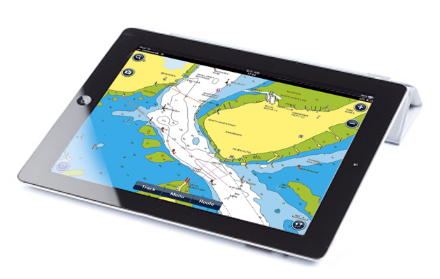
The development of navigation apps has now advanced to the stage where tablets are being used regularly by many sailors as a primary means of navigation on board. With the recent integration of wi-fi NMEA data to the mix, tablet navigation systems have found a permanent place in our arsenal of instruments.
I have selected seven of the best boating apps specifically focussing on new updates and innovative developments, but also with my eye on what our basic requirements for a good navigational app should be. Tests were carried out inshore, offshore, creek hopping, racing and just sitting at home on my sofa using an iPad 2 and an ASUS model P023 running Android 5.0.2.
Top rated iPad navigation apps – read individual reviews below
- Navionics and Navionics+ are a great duo – best on test.
- iNavX is good enough to replace on on-deck chartplotter.
- MaxSea TimeZero is brilliant if you want to use raster charts.
- Transas iSailor does everything, but it all costs extra.
- SeaNav UK & Ireland offers a unique ‘augmented reality’ view using Internet AIS.
- Garmin BlueChart Mobile good for planning, but only shares with Garmin hardware.
- iBoating is surprisingly versatile, but was the least expensive on test – and it showed.

The perfect iPad navigation app doesn’t yet exist but…
Having spent six weeks living and breathing these apps, I have come to the conclusion that the perfect one does not exist, but some are getting pretty close. The well-developed user interfaces that app-based products provide are far superior to those found on most chartplotters and now, with NMEA integration, the all-important GPS fix comes from an external feed overcoming any accuracy concerns around using the GPS receiver built in to the tablet.
To make the most of your chosen software, pick features that are relevant to your style of sailing. Think about what information you want displayed for easy situational awareness and make sure you spend time customising your display to show only what you need and, ideally, nothing more.
Crowd-sourced data
Crowd sourcing information has enabled the boating community to share local knowledge and update navigational features in real-time. Most apps now incorporate this in some way. A few apps are offering sonar mapping but Navionics also gives free access to its HD bathymetry Sonar Chart. This extra chart reveals more contours derived from a large database of sonar logs, which in many areas could provide more accurate charting than UKHO data.
Other crowd-sourced information includes the community edits, and the ‘Active Captain’ network, which is like an online almanac. If using this type of information for navigation check the date of the edit and treat new position info cautiously.
Article continues below…

Why paper charts still have a place alongside iPad and electronic navigation
When you open up any electronic navigation program you usually see a disclaimer telling you not to rely on its…

Google Earth navigation: how to sail off the chart with confidence using satellite imagery
Cruising in remote tropical regions can be challenging, especially where there are no charts suitable for pilotage. Often the charts…
Our top tips for using iPad apps for navigation: first thing, get a waterproof case!
Using iPad apps for navigation is becoming a popular option and we tested seven chartplotting apps for a feature in…
Top tips for setting up and using your iPad navigation device
Ports of refuge
Before setting off on longer passages ensure that you have downloaded the charts for any ports of refuge along the way and that your current package covers countries where you may conceivably need to make landfall.
Satellite image layers
Use satellite image layers, if available, to identify landmarks when approaching a new destination.
Check units: Lat and Long
Check your units when setting up an app. To help with easy communication of waypoints between charts, plotters and tablets ensure your position is reported in degrees, minutes and decimals. Many apps only use degrees and decimals to report positions, which could be confusing, particularly in an emergency situation.
Range rings
Set up range rings to use as clearing zones on navigational hazards, or even to indicate the three-boat-length zone around a mark when racing.
Velocity vector
The velocity vector shows you where you will end up after a specified amount of time. Set the value of this vector to one hour for help in predicting tidal offsets.
Chart updates
Check whether your chosen app includes chart updates and how they are accessed – many apps require a subscription after the first year to keep charts up to date.
This article updates the iPad navigation test from 2015. The links below are to the 2015 reviews that were not updated in the 2017 test
• Imray iPad app – Imray cartography • raster scanned charts • app free. Charts £29.99
• Plan2Nav – Jeppesen C Map • C Map cartography • vector charts • app free. Charts £26.99
• Memory Map – raster scanned charts • app free. Charts £25 UK and Ireland
See our Top Tips for using an iPad for navigation apps
 If you enjoyed this….

Yachting World is the foremost international magazine for bluewater cruisers and offshore sailors. Every month we have practical features to help you plan and prepare to realise your sailing dreams.Build your knowledge month by month with a subscription delivered to your door – and at a discount to the cover price. See our latest offers now.