
A good all-round package and especially versatile for ability to use raster and vector charts from multiple providers.
iNavX marine navigation app for iPad and iPhone
iNavX is the only app that allows access to charts from different providers – both raster and vector – using the same software. I tried NV raster and Navionics vector charts. Charts are purchased under a one-year license. After a year you get to keep the charts but without a further subscription you cannot update.
I loved the ability to switch between platforms without losing my stored waypoints, routes and tracks. The NV raster charts are high resolution even when zoomed in, but they are not quilted, so if working at large scale you may need to swap between charts quite frequently.
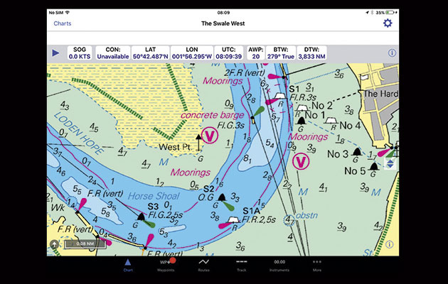
The user experience for navigating and planning is intuitive and comprehensive. Waypoint names are displayed on the chart, the entire waypoint layer can be switched off if desired, and it is possible to return to the same mark twice.
Instrument data is fed from the mobile device’s location system or from the onboard NMEA network via wi-fi. However, the app’s instrument panel definitely needs customising: on the default setting there is far too much information.
Other notable features include the ability to reduce track recording frequency (to preserve battery power) and the ability to set a variable range ring. Tidal information is not included in the iNavX package, but can be added with the additional purchase of the AyeTides app.
I would definitely use this package as an alternative to an on-deck chartplotter for racing or cruising. It offers just about everything you need and is very user friendly. It could also be a great resource if cruising abroad due to the large range of charts available.
Verdict
With charts included this is an expensive package but I could recommend it for all types of sailing with a great waypoint management for racing. The user interface is excellent, and ability to view different charts could be great for extended cruising especially in areas with open source charts. If you are only going to view Navionics charts then consider whether access to Sonar Chart would be important to you