
With Navionics+ this is one of the best iPad navigation apps, plus it works well on Android and iPhone too.
Navionics and Navionics+ marine navigation app for iPhone, iPad and Android
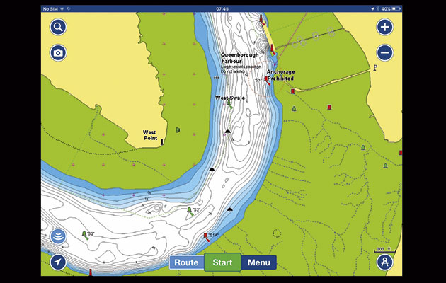
The basic functionality of the Navionics app is refined and good: scrolling and zooming are quick and receptive on iOS devices, although I found Android to be slower. The app includes tidal data displayed as current arrows and tide bars. Arrows will animate if interrogated and played forward through time. Tidal height bars do the same but also depths on the chart beneath will increase and decrease with the changes in tide.
You can customise the look: it is a one-touch operation to swap between the normal view and Sonar Charts view, there are various shading options for depth contours, and Easy View mode enlarges key navigational features so they remain visible even when the chart is zoomed out.
When first purchased, each region of charts includes Navionics+ for the first year. After that an annual subscription (£22.99 per year) must be paid to maintain Navionics+ features and download updates to charts. Bear in mind that without Navionics+ you can create markers and routes but there is no way to activate or follow a route. Navionics+ features include a full navigation window offering everything you would expect for following a route, the ability to create and store sonar logs with compatible instruments, and autorouting.
Autorouting plots a passage between a defined start and end point taking into account your draught and avoiding obstructions. I tested this feature and was impressed to see the app draw exactly the route I would have chosen in a matter of seconds. Plotter sync allows sharing of waypoints and routes between the app and compatible Raymarine plotters.
Navionics is not quite perfect, however. You can’t hide created marks, which can clutter the screen, created marks do not show their names on the chart and when creating a route for racing, it is not possible to return to the same mark twice – you cannot place two waypoints in exactly the same location.
Navionics is an easy-to-use all-round package and I definitely feel the yearly subscription fee for Navionics+ is worth it. The Sonar Chart feature offers a fantastic extra level of data.
Verdict
Easy to use all-round package. Navionics+ (£22.99 per year) is worth the extra subscription fee.