
There are many app options on the market for sailors wishing to navigate from a smartphone of tablet. Bruce Jacobs looks at some of the best navigation apps on the market.

It’s increasingly rare these days to see any sailor without at least one navigation application on their phone, while tablets are even preferred to fixed multifunction displays (MFDs) on an increasing number of yachts. It’s great to have this navigation information so easily to hand and so mobile, but which are the best navigation apps for sailors and how do they compare.
Sailors need slightly different information to motorboaters. It’s nice to know if it’s going to be sunny, but we care more about whether the tide will be foul or fair. We need to know what the wind direction will be and whether it’s going to be an angle we can use, over and above nearby places of interest.
We looked at the most popular navigation apps, particularly from a sailor’s perspective, and highlighted what we think works well for yachting and what is best left to the motorboaters.
The absolute number one benefit of an app is the ability to instantly see where you are, on up-to-date charts, without the cost and immobility of an MFD. Every app we tested has that core functionality and, ultimately, you will get good basic use out of any of them.
Thereafter, to my mind, most of these apps have been developed with the leisure powerboater in mind. They are focused on short day trips under engine or maybe going fishing to fairly well known areas. Wind, tide and current have little impact in these scenarios beyond whether it is sunny or the anchorage is accessible.
Fast and reliable
Having spoken to a range of sailors, it’s clear that the universal requirement is for an app that delivers fast, reliable data within an intuitive interface. We want charts that show sensible levels of detail as we zoom in and out and, critically, will warn us when we need to zoom in more to see dangers that might have been hidden by vector charts.
We then want all the other essential information such as wind and current instantly accessible and able to be overlaid on the chart, and we want to be able to quickly measure distance and bearing to a relevant point.
But despite some decent contenders, the truth is that not one app delivers it all. Adding in extras such as AIS, boat data, autorouting and more is great, but that foundation level functionality should come first.
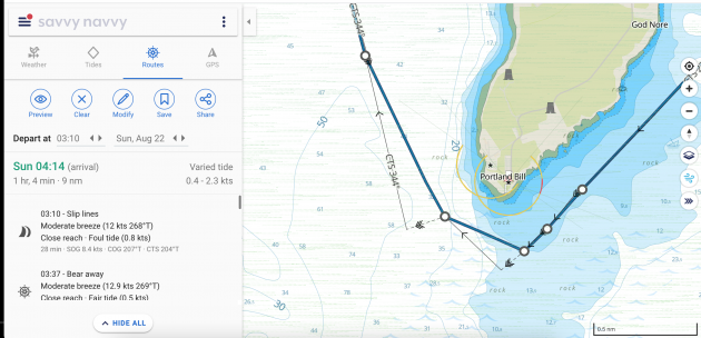
Savvy Navvy, the newcomer to the world of navigation apps, shows what the modern app could be. It is possibly the only app built with yacht sailors at the forefront and gives easily accessible wind, current and tide overlays to sensibly detailed charts. Its routing algorithm was the only app we tested that accounted for current, and its passage plans mapped out beautifully informative courses to steer.
It also recognises hazards such as tidal races and Traffic Separation Schemes (TSS). But its algorithm is too ambitious in the level of detail it tries to extrapolate from GRIB files and the app took us into dangerous shallows and routed us metres off hazards and lee shores in strong winds.
The app is nearly the absolute game changer it should be – but its programming sophistication has outstripped its seamanship and that’s an issue.
The other apps proved a mix in how suitable they are for sailors. Basic features such as wind and current were not universally available. Also often lacking were tools such as those measuring distance and bearing.
Frustrating menus
I found some of the routing software frustrating as I was made to go through multiple menus to load and select waypoints, rather than just touch two points on the screen. And some of the apps appear to have had data sources and functionality added over time, without the redesign they might then need to bring it all into one easy-to-use interface.
AIS data is a nice new feature, but some apps rely on an internet signal for it – others can link by wifi to your AIS device. Knowing how often internet signal drops on a yacht even close to land, I’m not sure I’d trust the type that doesn’t connect to the onboard AIS.
Crowd sourced data is also an increasingly common addition to the charts. Some love it for adding real time accuracy, but others claim it can be dangerously inaccurate. I suspect both are true so, as with everything, the prudent skipper should treat all information with a healthy dose of caution.
For the best mix of functionality, breadth of data and reliable information, Navionics + remains my app of choice. But if ( and it’s a big if) Savvy Navvy becomes more savvy with its seamanship – it will have everything it needs to revolutionise the sector and become the sailor’s app of choice.
Best Navigation apps for sailors:

C-Map on an iPhone
C-MAP
C-MAP produces my favourite charts, with just the right amount of detail for spot depths, enlarged navigational marks on land and sea and clever colouring.
Wind data via GRIB files is easily overlaid and the colour shading system both makes it easy to see predicted wind speeds and discourages the user from trying to extrapolate unrealistic detail.
However, there is no tide and current overlay, which is a frustration for sailors, and it is also a disappointment that there is no satellite imagery overlay.
C-MAP’s automatic routing system is fairly easy and intuitive to use but having allowed me to set a minimum depth of 3m, it would then suggest routes that contravened this limit, albeit giving a second option that didn’t. Some caution is therefore required.
Get C-Map app from the Apple App Store
Get C-Map app from the Google Play Store
Note: We may earn a commission when you buy through links on our site, at no extra cost to you. This doesn’t affect our editorial independence.
Read our full C-Map navigation app review

Navionics app on a phone
Navionics Boating app
This app is intuitive and easy to use. Charts are quick to render and auto zooming of detail is probably best in class. Text is used to good effect and tells you when you need to zoom in to get more information about hazards (one of the dangers of vector charts). Arrows showing current are animated to show strength, direction and whether the tide is on the ebb or flood. Frustratingly, you have to access a different window to get GRIB/wind data, when it should surely just be an option on screen.
The Navionics Sonar option allows charts to be adapted to show depths based on real time user data from thousands of vessels, but the company sensibly warns that many other factors (such as barometric pressure) will have a considerable affect on depths.
Get Navionics+ app from the Apple App Store
Get Navionics+ app from the Google Play Store
Read our full Navionics + navigation app review
Savvy Navvy app on desktop or tablet
Savvy Navvy
Savvy Navvy is a sophisticated app with all the key information ready to be switched on or off at your fingertips. It is the only app that has a routing algorithm that has inputs for wind and current (although bizarrely not leeway) and then plots a beautifully drawn course to steer. It is useful to be able to enter later or earlier departure times and see the impact on wind and tide.
Charts are a little light on detail for my liking – my sense being that artistic merit has slightly usurped navigational utility. A bigger issue with Savvy Navvy is that the sophistication of the programming for its route planning has not been matched by that of the seamanship. It extrapolates impossibly detailed wind patterns from the GRIB data and uses performance polars that cannot be adjusted – both of which make the plans interesting to look at but of little practical use.
Get Savvy Navvy app from the Apple App Store
Get Savvy Navvy app from the Google Play Store
Read our full Savvy Navvy navigation app review

Seapilot app on a phone
Seapilot
This app is based on some features of the professional ECDIS charting systems and in many ways has some of the best features – but while some will not agree, personally I found it unintuitive to use.
The significant issue, however, is that the autozoom on its charting detail just doesn’t work in many regions. Until I zoomed in to a small area (maybe five square miles) there was so much clutter on the screen that there was not much that could be done. Even when zoomed in, information about navigational marks would often be overlaid on spot depths, making both impossible to read. Seapilot acknowledges that some regions suffer from this as an issue due to the use of ECDIS data and hopes to rectify it going forward.
The app also uses ECDIS warning symbols for some hazards, which leisure sailors won’t be familiar with.
Get Seapilot app from the Apple App Store
Get Seapilot app from the Google Play Store
Read our full Seapilot navigation app review
isailor featues nice wind colouring
iSailor
iSailor is another app that works well as an extension to your boat’s onboard systems. It will connect to the NMEA system and internet AIS, although each feature you unlock costs money. The alarms menu is comprehensive, including anchor drag, waypoint proximity, loss of GPS signal and a low battery warning.
Charts were fairly good, but as with Seapilot, I had issues with the auto detail of the chart at various zoom levels and had data overlaid on each other. I also found that at certain levels of zoom, key data such as spot depth was removed, but too soon for my liking. If I want to plan 2-3 miles ahead I want to see clear depth data, not just coloured contours.
Get iSailor app from the Apple App Store
Get iSailor app from the Google Play Store
Read our full iSailor navigation app review

iNavx on a phone
iNavx
iNavX can be frustrating to use at first because there is so much to customise that it can be tough to get into. Persevere, however, and you’ll find a good app. It has a range of chart options including Navionics, C-MAP and NOAA. They partner with Waterway Guides, which gives micro level detail for marinas and other facilities, although the UK version is yet to arrive.
While all the information is there, I didn’t find interrogation of chart data as easy as, say, the Navionics app, but this may just be personal preference. I also found building and adjusting routes frustrating. There is a very comprehensive manual that can be accessed and a range of excellent YouTube instructional videos – but honestly, I’d rather just be able to work it out quickly and easily on the app.
Get iNavx app from the Apple App Store
Get iNavx app from the Google Play Store
Read our full iNavx navigation app review
 If you enjoyed this….

Yachting World is the world’s leading magazine for bluewater cruisers and offshore sailors. Every month we have inspirational adventures and practical features to help you realise your sailing dreams.Build your knowledge with a subscription delivered to your door. See our latest offers and save at least 30% off the cover price.